






- 1
- 2
Mapping architectural controversies
2010-10-29 14:26:46 - by
Rafaella Houlstan-Hasaerts
Mapping Architectural Controversies (MAC) is an interactive website dedicated to students and researchers working on controversies surrounding design projects, buildings, master plans, and urban and development issues. Documenting and visualising recent controversies in architecture, it also aims to address a broader audience interested in the design of cities, spatial networks and built environments as well as planners, representatives of city government, NGOs and citizens. As it is a part of the EU-funded project MACOSPOL, Mapping Architectural Controversies draws on a variety of documental sources and visual methods to explore the multifarious connections of architecture and society.
Haïti and the importance of open maps.
2010-02-08 11:30:32 - by
Nicolas Malevé
A bit after the fact, but still very interesting information. How Openstreetmap has been used to help NGO’s work in Haiti after the earthquake. A specific webpage has been set up for the occasion: http://www.openstreetmap.org.ph/
A thorough article by Camille Gévaudan, in ecrans.fr (in French).
Other informations in opensource.com
Quick selection of images:
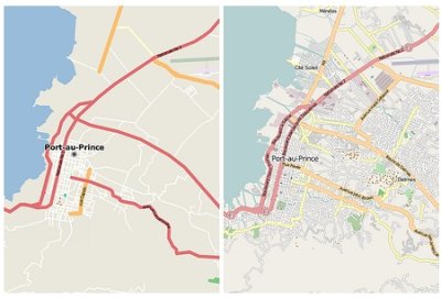
– Map showing the depth of flooding, using OSM road data.

– Port au Prince before and After
Can You See Me Know
2009-05-13 10:54:31 - by
Antoine Berlon
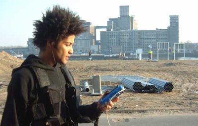
Blast Theory est un collectif de chercheurs s’intéressant à l’art et aux frontières délicates existantes entre les réalités physiques et numériques.
"Can You See Me Know" fut lauréat en 2003 du Golden Nica au festival Ars Electronica, à Linz en Autriche, dans la catégorie “interactive art”. Depuis cette nouvelle façon de "jouer la ville" ne cesse de voyager à travers le monde : Sheffield (2001), Rotterdam (2003), Tokyo (2005), et plus récemment Amsterdam (septembre 2007).
Le jeu se déroule parallèlement en ligne et dans les rues d’une ville. Des joueurs disposant d’une connexion à Internet peuvent participer en ligne, où qu’ils se trouvent, et jouer contre des membres de Blast Theory. “Trackés” (poursuivis) par satellite, ces membres apparaissent en ligne sur une carte de la ville, dans laquelle figurent également les joueurs en ligne. S’en suit un jeu du chat et de la souris, du gendarme et du voleurs, du gentil et du méchant aux règles extrêmement simples qui a pu perdurer dans le temps de par son efficacité. (Pour plus de détail, voir le site)
Gender Art Net
2009-05-12 16:21:04 - by
Antoine Berlon
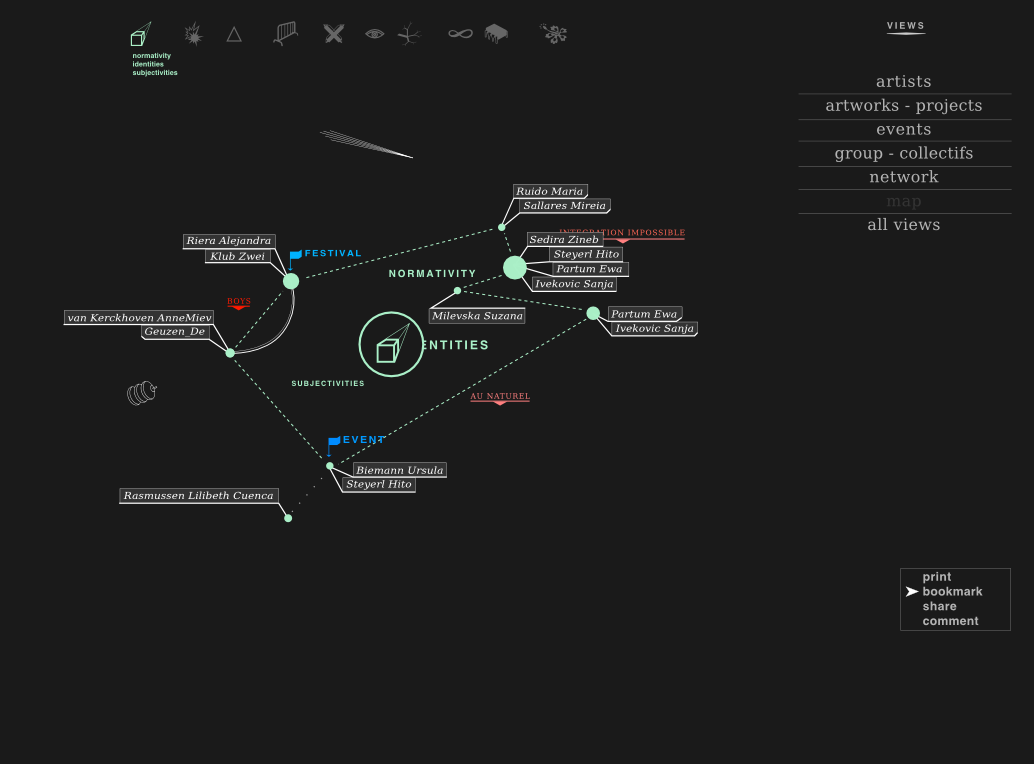
OSP participe actuellement au développement du projet Gender Art Net.
Gender Art Net propose de créer un atlas interactif donnant accès à différentes vues et lectures d’un ensemble de positions artistiques feministes dans l’Europe contemporaine.
Soutenu par l’European Cultural Foundation le projet est conçu par la productrice et commissaire Bettina Knaup, en collaboration avec Constant vzw. L’équipe du projet se compose de curatrices, artistes, statisticienne, développeurs, de Berlin, Barcelone, Amsterdam (Dunja Kukovec, Laurence Rassel, Diana McCarty, Maria Perez, Katalin Timar, Urska Merc) et d’étudiants le la section European Media Studies de l’Université de Postdam (Lenore Hipper, Inés Matres, Sebastian Moering, Laura-Helen Rüge)
Le projet explore les relations entre genres, territoires, artistes, œuvres, groupes, réseaux et événements à travers différentes thématiques / fils de discussions.
La base de données du projet se nourrit d’informations encodées par l’équipe éditoriale et d’informations extraites dynamiquement sur les sites web représentatifs des artistes.
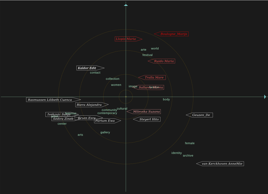
OSP travaille à rendre visibles, dynamiques et interactifs ces différents niveaux d’informations.
En collaborations avec Anne-Laure Buisson (statistician, feminist activist, Brussels), nous cherchons à distribuer/spacialiser un ensemble de mots clés significatifs en relation avec les artistes.
Les mots extraits des sites sont filtrés via des techniques de statistiques multi-variées pour générer des représentation en deux dimension reprenant les mots et les artistes, indiquant les relations entre eux et les particularités du lexique et des centres d’intérêts des artistes. Une série de graphiques, agissants comme des clichés ou petites cartes thématiques de l’atlas sont ainsi obtenus.
Plus d’informations Ici
Les informations encodées par l’équipe éditoriale localisent les lieux d’origine et de travail des artistes, associent les artistes à des fils de discussion et réseaux, et relient des œuvres/projets à des lieux.
OSP développe une interface qui permettra de parcourir en ligne cette carte feministe du ciel artistique européen.
Wikibivouac
2009-05-08 13:39:01 - by
Antoine Berlon
Wikibivouac is a collaborative map which reappropriates space to create new uses of the city.
The wiki element of contibutions from anyone aggregates information for improved transient occupancy of place.
To do this, the ZOOM team initiated the Hunting Days sessions, worldwide searches for locations of a particular resource - free, drinkable water points, one of the most critical resources to human existence. The first step was a venture into the streets Madrid in search of a free source of potable water. Discovering a fountain in the park, team members shot video to illustrate the potential uses of the resource, integrating the secnes into an instructional video introduceding the hunt and demonstrating the use of the interface to enter the points by street address or GPS coordinates. Data fields provided a way for hunters to enter info about the point, the way to access it, the times it is available, and other descriptive information. By the end of the first Hunting Day, (57) free drinkable water points had been entered into the database, and appeared in the worldwide map, with concentrations in Paris and Prague. When clicked, the points displayed the desciptive information which hunters had entered.
With the first hunt complete, focus shifted to the development of the openlayer tool which drives the Wikibivouac. Some points displayed at inaccurate locations. Developer Sami improved the accuracy of point placement from the interface, also creating a custom blue icon to represent water point locations. The points were shown by default on a black screen, but if users clicked the small plus-sign in the upper right corner, a small menu appeared which gave the option of viewing the points on two different map views.
After selecting the theme of the second hunt, a second instructional video was produced, keeping a humorous tone to encourage hunters to search for free warm spots where one can find shelter through the night. Again the object of the hunt was a free, available, underused resource important to human survival. The Wikibivouac collaborators await the results of the next hunt, which begins tomorrow.
See the site :http://www.wikibivouac.org/
Carte commune
2009-04-27 16:49:09 - by
Antoine Berlon
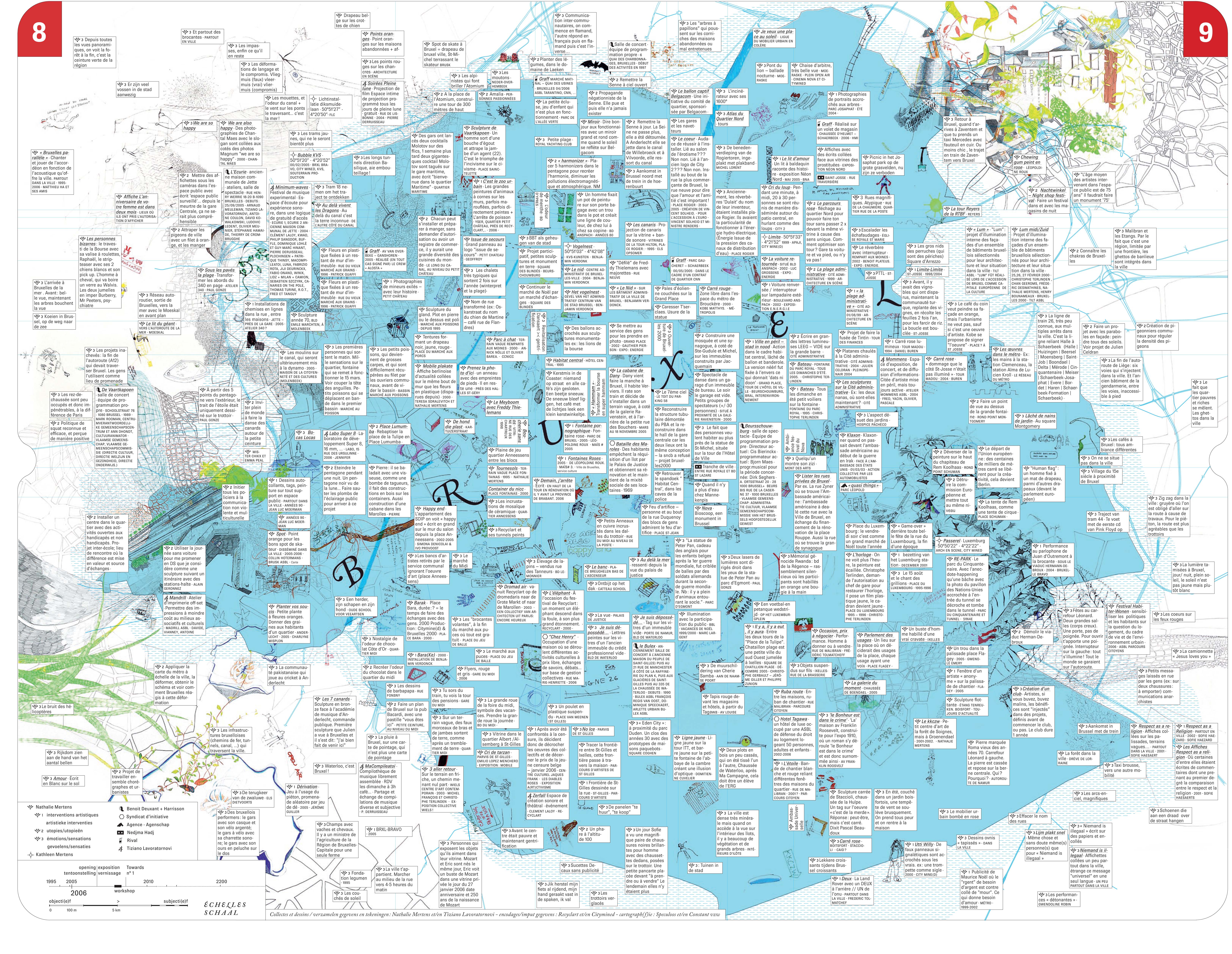
Suite à la première exposition Towards qui rendait compte des cartes subjectives d’interventions urbaines des artistes Nathalie Mertens, Nedjma Hadj, Tiziano Lavoratornovi, Harrisson et Benoît Deuxant, Agence, Rival, Katlheen Mertens et Syndicat d’Initiatives, le bureau de graphisme Speculoos s’est attelé à la tâche de faire communiquer ces différentes cartes, de rassembler les informations de chacune d’entre elles au sein d’une carte commune, afin de créer de nouveaux recoupements et des liens inattendus. Chaque artiste s’est vu proposer de remplir un tableau qui permettrait d’extraire une série de données communes : date de l’intervention urbaine, description de celle-ci, etc. L’hypothèse était que les liens se produiraient essentiellement par la concordance des données géographiques : deux cartes décriraient de manière différente le même point, ajouteraient des points de vue à la même paire de coordonnées. Contre toute attente, c’est la poésie brute des descriptions qui a servi de fil conducteur pour la création de cette carte commune, à la fois bande dessinée géographique et phylactère topologique de récits urbains.
OSM Party Brussel
2007-09-13 10:57:13 - by
Nicolas Malevé
16/09/2007: Open Street Map Party Brussel_ Brussel.
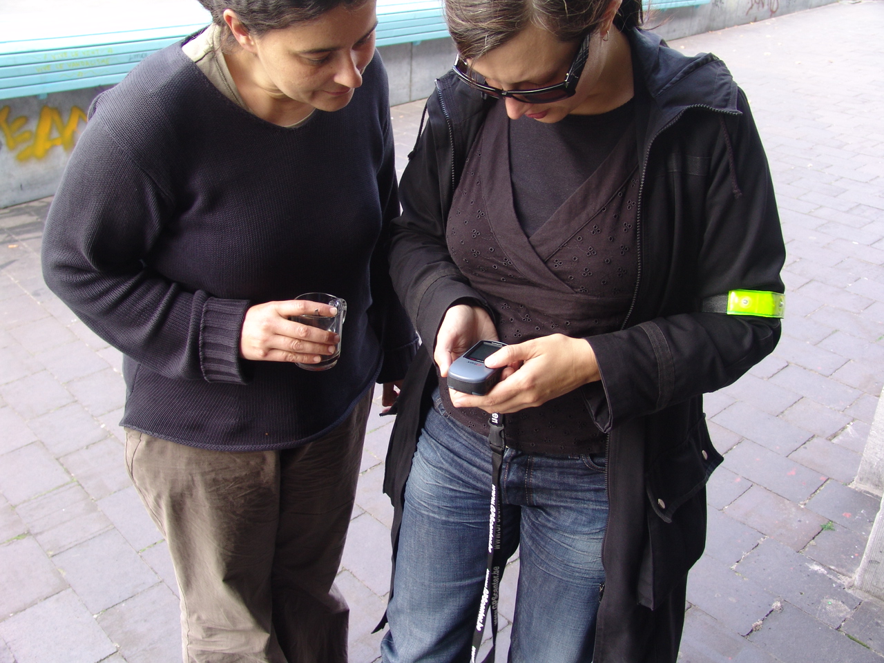
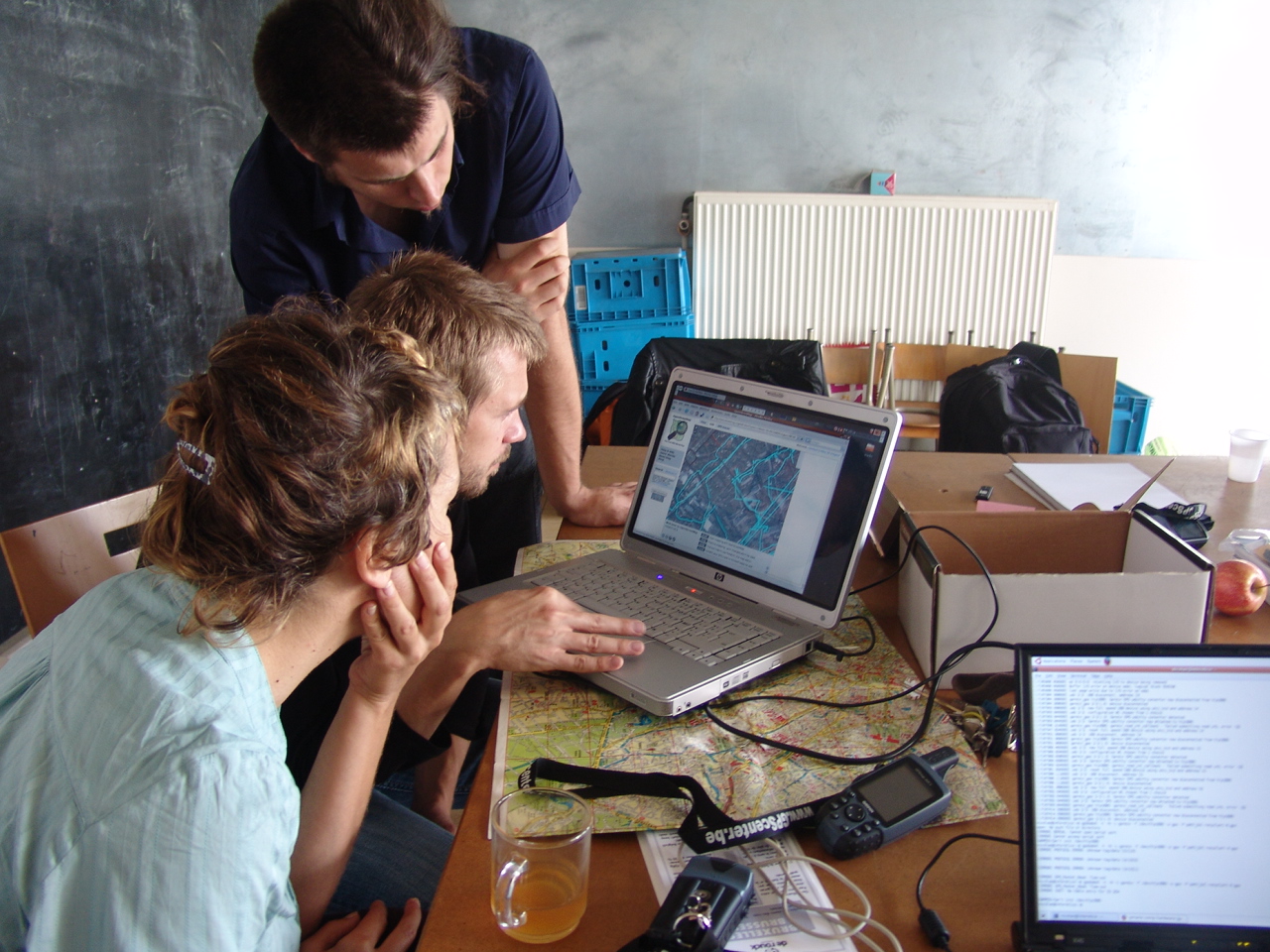
Op zondag 16 september organiseert Constant een Open Streetmap evenement.
We verzamelen GPS tracks in Brussel en voegen die toe aan de database van
Openstreetmap.org. Iedereen is van harte welkom om mee te fietsen en mee
te helpen de tracks te uploaden en annoteren. Het doel is om de gehele
vijfhoek van Brussel te traceren en in kaart te brengen. We zorgen voor
koffie, thee en een warme uitvalsbasis.
Heb je een fiets? neem hem mee !
Heb je een GPS? neem hem mee !
Als je geen fiets of GPS hebt, maar je zou er graag een willen gebruiken,
geef ons dan een seintje:
Constant heeft 6 GPS apparaten te leen en fietsen kunnen we regelen.
Onmoetingspunt:
-------------------
Zondag 16 september, 11:00
RECYCLART
Station Brussel-Kapellekerk
Ursulinestraat 25
1000 Brussel
Ons contacteren:
-------------------
Constant
Fortstraat 5,
1060 St. Gillis
Brussel
T / F: + 32 2 539 2467
E: osmap at constantvzw.com
******************************************************
Wat is OSM ?
-------------------
OpenStreetMap (http://wiki.openstreetmap.org) is een Vrije kaart van de
wereld, die wordt gemaakt door mensen zoals jij. Het OpenStreetMap project
maakt vrije geografische data zoals straatkaarten beschikbaar voor
iedereen. Het project is opgestart om een alternatief te bieden voor dure
commerciële kaarten met restrictieve licenties.
Waarom OSM ?
-------------------
Geografische informatie (geodata) is in grote delen van de wereld, zoals
Nederland en grote delen van Europa, niet vrij beschikbaar. Over het
algemeen zijn overheidsdiensten belast met het in kaart brengen van het
land en die diensten verdienen geld door de informatie te verkopen aan
belangstellenden.
Door de snelle technische ontwikkelingen zijn er nu goedkope
GPS-ontvangers en kan je, in samenwerking met anderen, je eigen kaarten
maken zonder alle genoemde beperkingen. Dankzij deze mogelijkheden winnen
we weer wat terug voor onze samenleving!
Meer vragen?
-------------------
check de FAQ op de Open StreetMap wiki
http://wiki.openstreetmap.org/index.php/Nl:FAQ#Waarom_maken_jullie_OpenStreetMap.3F
OSM Party Brussels
2007-09-13 10:53:21 - by
Nicolas Malevé
16/09/2007_ Brussels.
The aim of this day was to collect GPS tracks of Brussels and to add them to the database of openstreetmap.org., an interface that produces detailed maps that can be freely published, used to create portable navigation systems, carted away or printed and copied without any restrictions. The participants covered therefore the streets of the Pentagon in order to record these GPS tracks and helped to download them on the OSM server.
Organizers:
– Constant
******************************************************
What is OSM?
-------------------
OpenStreetMap (http://wiki.openstreetmap.org) is a Free map of the world,
made by people like you and me. "OpenStreetMap is a project aimed squarely
at creating and providing free geographical data such as street maps to
anyone who wants them."
Why OSM?
-------------------
"The project was started because most maps you think of as free actually
have legal or technical restrictions on their use, holding back people
from using them in creative, productive or unexpected ways."
How does it work?
-------------------
Contributors to the OpenStreetMap project take their GPS device on their
journeys or go off on organised GPS tracing events. They register names of
streets and villages and all other characteristics using a pen and paper,
a photo device or dictaphone.
Back behind their computers, they upload their GPS trace they made during
their voyage and trust their routes to the collaborative database of
OpenStreetMap. Using their notes, the contributors add streetnames and
info about the type of route or path and connections.
The data is then treated to produce detailed maps, which can be published
on sites such as Wikipedia, which can be used to create portable,
embedded, printed navigation systems which can be copied without limits.
More info?
-------------------
Read the FAQ on the wiki:
http://wiki.openstreetmap.org/index.php/FAQ
OSM party Bruxelles
2007-09-13 10:45:44 - by
Nicolas Malevé
16/09/2007_ Bruxelles.
Le but de cette journée était de collecter des traces GPS de Bruxelles pour les ajouter à la base de données d’openstreetmap.org., une interface qui produit des cartes détaillées qui peuvent être publiées librement, utilisées pour créer des systèmes de navigation portatifs, embarquées ou encore imprimées et copiées sans restrictions. Les participants ont donc parcouru les rues du pentagone à bicyclette afin d’enregistrer ces traces GPS, pour ensuite aider à les télécharger et les annoter.
Organisateurs :
– Constant
******************************************************
Qu’est-ce qu’OSM ?
-------------------
OpenStreetMap (http://wiki.openstreetmap.org) est une carte mondiale
Libre, qui est faite par des gens comme vous et moi.
"OpenStreetMap a pour objectif de créer et fournir des informations
géographiques libres telles que des plans de rue à toute personne le
désirant."
Pourquoi OSM ?
-------------------
"Le projet fut démarré car la plupart des cartes qui semblent libres ont
en fait des restrictions d’utilisation légales ou techniques, empêchant
de
les utiliser de manière créative, productive ou tout simplement selon vos
souhaits."
Comment cela marche ?
-------------------
Les contributeurs d’OpenStreetMap emportent leur GPS portable en voyage
ou
sortent spécialement pour enregistrer des traces GPS. Ils enregistrent
les
noms des rues, les noms des villages et toute autres caractéristiques en
utilisant un carnet, un appareil photo ou un dictaphone.
De retour devant leur ordinateur, les contributeurs téléchargent la trace
GPS indiquant leur trajet et dessinent les routes sur la base de données
collaborative d’OpenStreetMap. En utilisant leurs notes, les
contributeurs
ajoutent les noms des rues, des informations sur le type de route ou de
chemin et les connections entre les routes.
Les données sont alors traitées pour produire des cartes détaillées, qui
peuvent être publiées librement sur des sites tels Wikipedia, utilisées
pour créer des systèmes de navigation portatifs ou embarqués ou imprimées
et copiées sans restrictions.
Plus d’infos ?
-------------------
Lire la foire aux questions du wiki :
http://wiki.openstreetmap.org/index.php/FAQ
Cognitive and cartographic representations
2007-09-06 13:21:23 - by
Nicolas Malevé
A dense paper that tackles many important themes for a subjective collective cartography: data collection from subjective perception of space, the comparison of subjective datasets, how to map them, which protocols to use, etc.
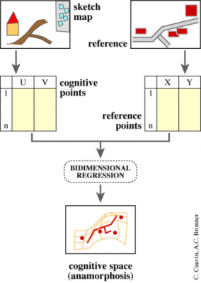
"In order to clearly understand the cognitive representations of the urban space, this paper presents an approach in three steps : identification, which highlights the importance of a place ; its location more or less exact which indicates the level of the individuals’spatial knowledge, and the description which specifies the significant attributes of these places for the interviewed individuals. In order to obtain comparable maps, a precise protocol is proposed for each step."
Colette Cauvin, « Cognitive and cartographic representations : towards a comprehensive approach », Cybergeo, Cartographie, Imagerie, SIG, article 206, mis en ligne le 15 janvier 2002, modifié le 03 mai 2007. URL : http://www.cybergeo.eu/index194.html. Consulté le 04 septembre 2007.
OPENSTREETMAP in Brussels this Sunday
2007-07-20 10:26:10 - by
Nicolas Malevé
Benjamin Henrion who joined the July cartography workshop talked about the openstreetmap project(1). This Sunday, he will organise a first test of open cartography of the center of Brussels.
How do we do?
Meeting Point at 10 AM Brussels Grand Place with your bike and a GPS. We will wander through the streets of the city center.
Meeting Point at 1PM at Constant’s office 5 rue du Fort, 1060 Brussels to process the data acquired in the morning and upload them on the openstreeetmap’s website. http://www.openstreetmap.org/
Please add yourself on the participants list here.
(1) about openstreetmap:
OpenStreetMap is a project aimed squarely at creating and providing free geographic data such as street maps to anyone who wants them. The project was started because most maps you think of as free actually have legal or technical restrictions on their use, holding back people from using them in creative, productive or unexpected ways.
And:
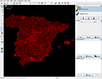
Spanish OSMers got permission to import goverment data into OSM. The first task has been importing the "ROI" geodesy network; supposedly this is the first time that data from a National Mapping Agency is imported directly into OSM. "ROI" stands for "Red de Orden Inferior", or "Lesser Order Network".
Cartographie collective et participative de l’Afrique
2007-07-15 12:23:14 - by
Véronique
Cartographie collective et participative de l’Afrique... par des voyageurs... Données mise à disposition gratuitement de la communauté tracks4africa et vendues par ailleurs
Using GPS devices, the Tracks4Africa (T4A) community when touring Africa do meticulous record keeping of their travels. From this huge repository of high quality GPS data we have created a super accurate GPS map called the T4A Map. But the T4A Map is more than that, it is the collective navigational experience of the T4A community over the past 7 years. It shows Africa the way it is and how it is constantly changing. Click here for more informaton about Tracks4Africa’s maps.
Professed by the late Jan Joubert, we believe that conservation of environmental resources depends on access to INFORMATION and for the traveller to be INFORMED. This is the 4th dimension of eco-travel and it is the focus of Tracks4Africa.
We invite everyone with a GPS to join this pan African mapping initiative aimed at creating a popular African GIS culture where everyone can give a contribution towards the re-mapping of Africa ; to contribute by email your GPS track logs, waypoints, photos and INFORMATION which will ensure eco-tourism that is safe and environmentally correct.
Please note that this initiative is not aimed at mapping major urban centres (often for cities very good quality data already exists) but rather to focus on rural and remote Africa. Tracks4Africa also serves to impact positively on the small business initiatives (craft markets and community rest camps) of people in rural and remote parts of Africa.

- 1
- 2
